Namma Metro Pink Line on Bannerghatta Road
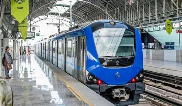
The Pink Line is the single largest change coming to Bannerghatta Road. It is the first rail-based link the corridor has ever had to central Bengaluru, and for a road whose defining problem is road traffic, that is a structural change rather than a cosmetic one. It is also, at the time of writing, not carrying passengers on any section.
This page sets out what the line is, which stations are on this corridor, and when the first stretch of it is expected to start running. The short version: the elevated Bannerghatta Road section was due to open on 15 August 2026 and has been reported as missing that deadline, with late August or early September now expected. That is an expectation, not a commitment, and the rest of the page explains why the difference matters.
What the Pink Line Is
The Pink Line is Reach 6 of Namma Metro's Phase 2, built by the Bangalore Metro Rail Corporation Limited (BMRCL). It runs about 21.25 km from Kalena Agrahara on Bannerghatta Road in the south to Nagawara on the Outer Ring Road in the north, with 18 stations. Unusually for Namma Metro, most of it is underground: roughly 13.92 km in tunnel, 6.98 km elevated and a short at-grade section, with 12 underground stations and 6 elevated ones.
Geographically it is the line that finally connects Bengaluru's southern suburbs to its centre and its northern residential belt in one ride. From Bannerghatta Road it runs through Jayanagar and JP Nagar, into the tunnelled central section past Dairy Circle, Langford Town, MG Road, Shivajinagar and Cantonment, and out again through Pottery Town, Venkateshapura and Kadugondanahalli to Nagawara. The elevated southern section and the tunnelled central section are, in engineering terms, two quite different pieces of work, which is why they are being commissioned separately.
The Bannerghatta Road Stations
Six stations on the line are on Bannerghatta Road itself, running from south to north:
- Kalena Agrahara, the southern terminus of the line, and the nearest Pink Line station to Bilwaradahalli at 6.3 km, though it is not open yet. It was named Gottigere in earlier BMRCL documentation, so older maps, tender papers and news reports use that name for the same station. If you are cross-reading sources, treat the two as one place.
- Hulimavu
- IIMB, serving the Indian Institute of Management Bangalore campus.
- JP Nagar 4th Phase, an approved interchange with the Orange Line.
- Jayadeva Hospital, the corridor's most significant station, and the interchange with the Yellow Line.
- Tavarekere, the northern end of the first stage, and the point at which the underground section begins.
Why Jayadeva Hospital matters
Jayadeva Hospital is an interchange between the Pink Line and the Yellow Line, the latter running from RV Road toward Bommasandra along the Hosur Road corridor. It is a multi-level structure built over an existing road underpass and a double-decker flyover, with the Yellow Line and Pink Line platforms stacked above them, the first station of its kind on the network. Practically, it is the point at which a passenger from Bannerghatta Road can change onto the Electronic City corridor without going into the city centre first. For anyone on this road whose work is in the south-east of Bengaluru, that interchange is the most consequential single item on the whole line.
The Two-Stage Opening Plan
BMRCL is commissioning the Pink Line in two stages rather than end to end:
- Stage one, the elevated southern section, roughly 7.5 km from Kalena Agrahara to Tavarekere, covering all six Bannerghatta Road stations.
- Stage two, the remaining stretch, 13.76 km from Tavarekere to Nagawara, which is the tunnelled central and northern section. Dairy Circle is a station on it rather than its southern end; the underground alignment begins where the elevated one finishes, at Tavarekere. The Greater Bengaluru Development Minister's stated deadline for the full corridor is March 2027.
The sequencing is a straightforward consequence of construction difficulty. An elevated viaduct on a wide arterial road finishes faster than twin bored tunnels and twelve underground stations through the oldest and most congested part of the city. The practical effect for a Bannerghatta Road resident is that the corridor's own stations are expected to open first, but that the trip they will initially serve ends at Tavarekere, not in the centre. Until the underground section is commissioned as well, the line is a shuttle along part of one corridor rather than a cross-city route.
The Current Timeline, and Why It Is Not a Promise
The elevated section, Kalena Agrahara to Tavarekere
The elevated stretch is 7.50 km and carries all six Bannerghatta Road stations. It was due to open on 15 August 2026, a deadline set by the Greater Bengaluru Development Minister, Krishna Byre Gowda. Deccan Herald reported in July 2026 that it was likely to miss that deadline and is now expected in late August or early September, with signalling validation still to be completed before the statutory safety inspection can be carried out.
The headline on that report was delayed again, and the word doing the work is again. This is not the first slip, which is the whole reason a date on this line should be read as an expectation rather than a commitment. Note the modality in the reporting too: likely to miss, expected in late August or early September, on the account of people familiar with the work. Nobody quoted is promising a day.
The word again is documented rather than rhetorical. The published sequence for this stretch runs:
- December 2025, the earlier planned date, missed.
- 15 August 2026, the replacement deadline, and the one still carried by the reference entry for Kalena Agrahara station, marked to be confirmed. Now reported as also going to be missed.
- Late August or early September 2026, where the expectation stands as this is written.
Three targets, two of them already missed. That is the case for checking BMRCL yourself rather than trusting a secondary source, and note that the station reference page has not caught up either, which includes, in principle, this one. Anything written about a date on this line has a shelf life.
Kalena Agrahara, the station nearest this end of the road
Kalena Agrahara was named Gottigere in earlier documentation, which is worth knowing on this corridor: Gottigere is the postal head office for the project's own 560083 pincode, so the old name is the one a local will use and the one older maps and tender papers carry. The station is the line's southern terminus rather than an intermediate stop, and that is a genuine advantage for anyone boarding here, a terminus platform means joining a train at the start of its run rather than one that is already loaded. It is elevated, with three tracks across a side platform and an island platform: Platform 1 terminates, Platforms 2 and 3 run north toward Tavarekere. The published address is Mantri Residency Road, near Sri Meenakshi Sundareshwara Temple, Classic Orchards Layout, Kalena Agrahara, Bengaluru 560076.
Its status is given as final stages before operations, construction essentially complete, commissioning outstanding, which squares with the reporting that signalling validation, rather than civil work, is what remains. There is no interchange at the station itself; the nearest are JP Nagar 4th Phase (Orange Line) three stations north, Jayadeva Hospital (Yellow Line) four, and Dairy Circle (Red Line) five. From Nambiar Beverly Park it is 6.3 km away, and it is not open.
The underground section, Tavarekere to Nagawara
The underground stretch is 13.76 km with twelve stations, running from Tavarekere to Nagawara. Dairy Circle is a station on it, not its southern end; the tunnels begin where the viaduct finishes.
The date for it comes from the same minister who set the 15 August elevated deadline. In June 2026, Krishna Byre Gowda gave the elevated stretch by August 2026 and the full corridor by March 2027, reported by The Hindu on 19 June 2026 and by The New Indian Express, whose headline was that the deadlines had been pushed again. March 2027 is therefore a ministerial commitment reported by two national outlets rather than an inference, which makes it the best available figure, and still a deadline set by the same office whose previous two have moved.
The record, in one place
Set out end to end, the published sequence is the most useful thing this page can give a buyer:
| Section | Target | Where it comes from | What happened |
| Elevated, Kalena Agrahara to Tavarekere | December 2025 | Earlier planned date | Missed |
| Elevated, Kalena Agrahara to Tavarekere | 15 August 2026 | Greater Bengaluru Development Minister, June 2026, reported by The Hindu and The New Indian Express | Reported in July 2026 as going to be missed |
| Elevated, Kalena Agrahara to Tavarekere | Late August or early September 2026 | Deccan Herald, July 2026 | Where the expectation stands |
| Full corridor, through to Nagawara | March 2027 | Greater Bengaluru Development Minister, June 2026, reported by The Hindu (19 June) and The New Indian Express | Outstanding |
Two of the three elevated targets have already been missed, and the New Indian Express headline on the June statement was that the deadlines had been pushed again. That is not an argument for ignoring the line, it is being built, and the civil work at the southern end is essentially finished, but it is a conclusive argument against treating any single date as settled.
It is also why every date here is attributed rather than asserted, and why the last word belongs to BMRCL rather than to this page. Reference pages elsewhere have not kept up, the station entry for Kalena Agrahara still carries 15 August 2026, and anything written about a date on this line, including this, has a shelf life.
That first date has already moved. The elevated section was previously targeted for 15 August, and it slipped to allow two things to finish: pending signalling validation, and the statutory inspection by the Commissioner of Metro Rail Safety (CMRS). Neither is a formality. The CMRS certificate is the legal precondition for carrying passengers, and it is issued when the inspection is satisfied rather than when a calendar says it should be.
That is why this page gives you a window rather than a day, and names no single date for the start of service. Commissioning an Indian metro depends on statutory safety clearance, rolling-stock availability and signalling trials, none of which can be scheduled with confidence in advance. The pattern across Namma Metro's own history has been that announced dates slip and then firm up only weeks before the service actually starts. A date five weeks out is exactly the kind that moves.
Once trains are running on the elevated stretch, the journey from Bannerghatta Road to the city centre is expected to take about 25 minutes. That figure is a projection for a line that has not yet carried a passenger, treat it as the designed intent, not as a measured travel time, and check it against reality after the service opens.
What follows for a buyer is a rule as well as a date: do not underwrite a property decision on a metro opening date, including this one. If the date matters to your decision, check it yourself, close to the moment you decide, at bmrc.co.in, and read what BMRCL says rather than what someone says BMRCL said.
What It Means for the Southern Reach of the Corridor
Two honest caveats apply to any project on the far southern end of Bannerghatta Road, including Nambiar Beverly Park at Bilwaradahalli.
First, Kalena Agrahara is the southern terminus, and the terminus is not the end of the road. The line stops well short of the park country where the villa formats are. A project south of Gottigere is not a metro-adjacent project; it is a project on a corridor that has a metro on part of its length.
The distances are now measured, and they say the same thing more precisely. From Nambiar Beverly Park, Kalena Agrahara is 6.3 km away and is not open, it was due to open on 15 August 2026 and is now reported as expected in late August or early September, on the timeline set out above. The nearest metro station in service today is 12.5 km away: Yelachenahalli or Silk Institute, both at the southern end of the operational Green Line. Anyone tempted to read 6.3 km as a commuting figure should read it with the words not open attached, and plan around the 12.5 km instead. What the line changes, when it runs, is the corridor's overall accessibility and the way the market values road frontage along it, a directional effect, not a walkable-station effect.
Second, station catchments in Bengaluru have historically been served by feeder buses, autos and private drop-offs rather than by walking. Parking at a terminus station is the practical constraint on whether a driver from further south uses the line at all. That is a question worth asking BMRCL, not a developer.
Checking the Current Position
Go to BMRCL directly at bmrc.co.in for the network map, the current commissioning status and fare information. Cross-read it against contemporaneous reporting rather than against project marketing pages, which have an incentive to be optimistic and rarely date their claims.
For how the corridor is laid out around this project, see the Nambiar Beverly Park location page, and for other guides to the road and the buying process, the Nambiar Beverly Park blog.
Explore Nambiar Beverly Park