Bannerghatta National Park
Bannerghatta National Park is the green anchor at the southern end of Bannerghatta Road. It covers 260.51 sq km, with the 731.88-hectare Bannerghatta Biological Park carved out of it and the Nature Camp run by Jungle Lodges & Resorts, 3 km from Nambiar Beverly Park.
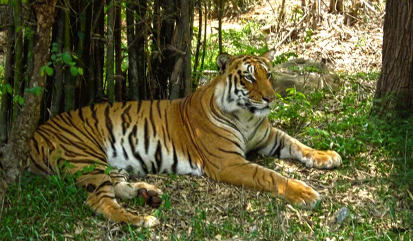
Bannerghatta National Park is the reason this end of the corridor is different from every other Bangalore arterial, and it is the honest differentiator for Nambiar Beverly Park. The park was founded in 1970 and declared a national park in 1974; it covers 260.51 sq km and is contiguous with the Talli reserve forest to its south-east and the Bilikal forest to its south. It forms part of a wildlife corridor used by elephants that connects the BR Hills and the Sathyamangalam forest. Because Bannerghatta Road runs into this rather than into the next suburb, there is a permanent southern limit to how far the built city can spread down the corridor. The project is at Bilwaradahalli on that reach, 3 km from the Bannerghatta Nature Camp, a measured distance, as are the ten school distances on the schools page, the eight hospital distances on the hospitals page, and six mall and six tech-park distances on the location pages. Three metro-station distances are also measured and published, 12.5 km to Yelachenahalli and to Silk Institute, both operational, and 6.3 km to Kalena Agrahara, which is not open yet. Electronic City is 15 km away, 30 min by car, 30 min by bike, and Kempegowda International Airport is 68 km away, 2 h by car, 1 h 58 min by bike. Three BMTC bus stops complete the set: 190 m to Bilavaradahalli Cross, which is limited at about fourteen departures a day; 1.5 km to Bilavaradahalli and 2.3 km to Bannerughatta Circle, which carry the frequent Majestic routes. Every landmark this website names carries a measured distance.
The Park, the Biological Park and the Nature Camp
Three names get used interchangeably in property marketing and they are not the same thing. Getting them straight is the first step to judging what the green edge here is actually worth.
Bannerghatta National Park
The protected area itself: 260.51 sq km of dry deciduous and scrub forest and hill country south of the city, founded in 1970 and notified as a national park in 1974, contiguous with the Talli and Bilikal forests and part of a working elephant corridor. It is administered by the Karnataka Forest Department. Public access to the park proper is limited and regulated, this is not open parkland, and it should not be imagined as an amenity you walk into. It is also under pressure: published analysis records that the dry deciduous forest within the park shrank by roughly 44% between 1995 and 2021, which is context worth carrying when you read anyone's claims about permanence.
Bannerghatta Biological Park
In 2002 a portion of the park was carved out as a zoological establishment, the Bannerghatta Biological Park, covering 731.88 hectares within the Anekal revenue taluk of Bangalore Urban district. This is the part the public actually visits: the zoo, the safari, lion, tiger and bear, the butterfly park and the rescue and rehabilitation centre. The Butterfly Park opened in 2006 across about 7.5 acres and was India's first, developed with the Zoo Authority of Karnataka, the University of Agricultural Sciences Bangalore and the Ashoka Trust for Research in Ecology and the Environment.
Bannerghatta Nature Camp
The camp run by Jungle Lodges and Resorts on the Biological Park campus. Published address: Bannerghatta–Kagalipura Road, near Hakki-Pikki Colony, Bannerghatta, Bangalore 560083. It offers tented and log-hut accommodation, safaris and naturalist-led herbivore treks, and it is the landmark that anchors this project's verified distance on the park side: 3 km from the site at 12.823744° N, 77.571837° E. That single fact describes the address better than any other, three kilometres from a forest camp, on a road that still runs city buses.
Living Near the Park Edge
Property marketing tends to present a forest boundary as pure upside. It is not; it is a set of specific advantages and specific constraints, and a buyer paying villa prices deserves both.
What it gives you
- A ceiling on sprawl. The road terminates in protected forest, so the southern reach cannot fill in the way that comparable distances on other arterials have. Green here is structural, not landscaped.
- Air, quiet and sightlines that are measurably different from the built stretch of the corridor, the practical, everyday benefit of low density and a large forest block upwind.
- Weekend life on the doorstep. The Biological Park, the safari and the butterfly park become a standing family outing rather than an annual trip.
- A recognisable address. Bannerghatta is a name buyers and tenants already know, which matters for resale and for letting.
What it costs you
- Weekend traffic. The road carries visitor traffic toward the Biological Park that it does not carry midweek. Plan Saturday and Sunday errands accordingly.
- A live human–wildlife interface. This is a working elephant corridor landscape; the Forest Department manages it actively and it is a real feature of the region, not a brochure flourish.
- Regulatory sensitivity. Land near a protected area carries planning and environmental constraints that land in the middle of a city does not.
- Distance from services. Hospitals, malls and the metro terminus under construction are all north of you, and there is only one road to them. See the hospitals page and the connectivity page.
The Wider Green Belt on This Side of the City
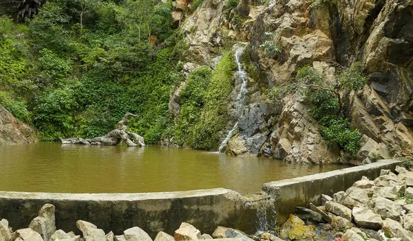
Bannerghatta is not an isolated patch. The same State Highway 87 continues past the park toward Jigani and Anekal, and beyond Anekal lies Muthyala Maduvu, Pearl Valley, a small waterfall and wooded valley that makes an easy half-day trip from this end of the corridor. Southward the national park is contiguous with the Talli reserve forest and the Bilikal forest, so the green does not stop at the park boundary on a map. This is the practical reason the southern reach of Bannerghatta Road reads differently from the rest of urban Bangalore: the land use to the south is forest and plantation for a long way, and that is a function of geography and protection status rather than of any developer's landscaping.
Visiting, Practically
The Biological Park is a full day if you take the safari and the butterfly park together, and it is busiest at weekends and during school holidays. Timings, entry and safari booking are set by the Zoo Authority of Karnataka and change from time to time, check the Biological Park's own site before you go rather than relying on any third-party listing. The Nature Camp is booked through Jungle Lodges and Resorts. If you are visiting the project, going on to the camp afterwards is the single most useful thing you can do to understand the address, it is the one distance on this site we can stand behind, and it is worth experiencing rather than reading.
How This Should Weigh in a Purchase Decision
The green edge is genuine and it is structural, which is more than most Bangalore projects can say about their surroundings. It is also not a substitute for diligence. Treat the forest as the reason the locality will keep its character, and treat the service position, hospitals, schools, metro, on its own merits, which are set out on the hospitals, schools and connectivity pages. The locality itself is described on the Bilwaradahalli page, and the address, coordinates and corridor overview on the location page.
*This page carries one measured distance, 3 km to the Bannerghatta Nature Camp; the measured school distances are on the schools page. Park figures are as published by the sources cited.
Frequently Asked Questions
1. How close is Nambiar Beverly Park to Bannerghatta National Park?
The measured distance is 3 km from the site to the Bannerghatta Nature Camp, run by Jungle Lodges and Resorts on the Biological Park campus. No distance is given to the park boundary itself: it is not a single point, so none has been measured.
2. What is the difference between the national park, the Biological Park and the Nature Camp?
The national park is the protected area, 260.51 sq km. The Biological Park is the 731.88-hectare zoo, safari and butterfly park carved out of it in 2002, what visitors actually enter. The Nature Camp is the Jungle Lodges and Resorts property on that campus.
3. What is it actually like to live near a national park edge?
It gives you a hard ceiling on sprawl, and better air and quiet than the built stretch of the corridor. It costs you weekend visitor traffic, a live human–wildlife interface, and a drive north for hospitals, malls and the metro. Price both halves.
4. Will the forest stay?
The structural limit on southward sprawl is real: the protected area is a national park and the road terminates in it. That is not a guarantee of no change, published analysis records forest inside the park shrinking by roughly 44% between 1995 and 2021.
Explore Nambiar Beverly Park