Nambiar Beverly Park Phase 1 Layout
The Nambiar Beverly Park Phase 1 layout opens 36 acres of the 76-acre development at Bilwaradahalli on Bannerghatta Road, and sets out 298 villa plots within it. The drawing shows a single controlled entrance with a plaza, a dedicated bus bay and a retail block at the gate; a road hierarchy of 12 m and 12.19 m internal roads with 9.14 m secondary roads; and six landscaped parks running along the southern boundary. About half the land is villa plots; the rest is roads, parks and open space. Two high-tension electrical alignments are drawn on the same sheet, and a group of plots near the east entrance is annotated "to be amalgamated", both are covered below, because a buyer will see them on the plan and should have them explained rather than glossed over.
This page reads Phase 1 as it is drawn. The size-by-size breakdown of the 298 plots is on the plot mix page, the margins each house is built within are on the setbacks and building envelope page, and the whole scheme in summary is on the master plan.
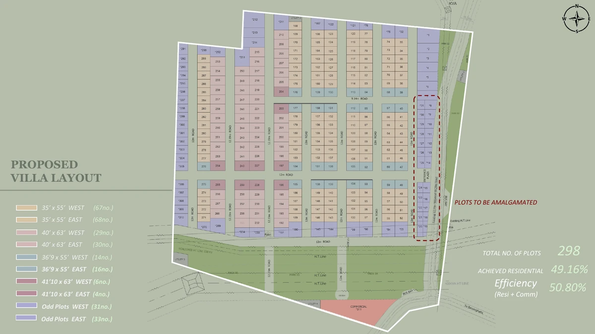
What Phase 1 Opens
Phase 1 is the portion of the 76 acres that has been drawn up and dimensioned. Nothing has been published about how the remaining land will be divided, when it will be taken up or what will go on it, so this page treats Phase 1 as the whole of what a buyer can presently see.
- 36 acres of the 76-acre development.
- 298 villa plots, each sold with the G+2 villa built on it.
- About half the land is villa plots; the rest is roads, parks and open space.
- 12 m and 12.19 m internal roads, 9.14 m secondary roads.
- Six landscaped parks along the southern boundary.
- A single entrance plaza with a dedicated bus bay, and a retail block at the gate.
How Much of Phase 1 Is Villa Plots
About half of Phase 1 is villa plots. The rest is roads, parks, services and open space.
That is a normal, unremarkable number for a villa layout with wide roads and a landscaped edge, and it is worth reading the right way round: the balance that is not plots is the roads you will drive on, the parks along the southern boundary and the space the services run through. Fitting more plots in would mean narrowing those roads or shrinking the open space. No overall open-space percentage has been published for this project, and none is quoted here.
The Road Hierarchy
The layout runs three road widths. 12 m and 12.19 m carry the main internal movement, and 9.14 m secondary roads serve the shorter runs between plot clusters. A 12 m section is generous for a residential layout, it leaves room for two-way movement, an occupied visitor car at the kerb and a planted verge at the same time, which is the combination that usually fails in older villa schemes once every household owns two cars.
The practical consequence for a buyer is that the road in front of the plot you choose is not all one thing. Ask which width fronts your plot: a 12.19 m frontage and a 9.14 m frontage are different amounts of noise, different turning circles for a delivery vehicle, and different amounts of light reaching the front setback.
The Entrance: Plaza, Bus Bay and Retail Block
All movement into Phase 1 passes through one entrance. The plan gives that entrance an entrance plaza, a dedicated bus bay and a retail and commercial block, grouped together at the gate rather than distributed through the layout.
The bus bay is the detail worth noticing. School transport and staff transport in a villa community of this size generate a lot of stopping, and a bay lets that happen off the carriageway instead of on Bannerghatta Road. Putting the retail block at the gate does the same job for a different traffic type: shop deliveries and non-resident customers never need to enter the residential streets. Tenant mix, built-up area and the operating hours of that block have not been published.
The Six Parks on the Southern Boundary
Six landscaped parks run along the southern edge of Phase 1. They give the plots on that side a green frontage and give the rest of the phase somewhere to walk to. What has not been released is the landscape specification, no planting schedule, no play equipment list, no built structures, no lighting or paving detail. The parks are drawn as areas on the plan; their content is unstated. There is more on this on the parks and landscape page.
The High-Tension Lines on the Plan
Two electrical alignments appear on the Phase 1 drawing, and both should be discussed openly because a buyer will see them.
- A 220 kV HT line has been realigned along the southern boundary, the same edge as the six parks. Realignment means the route has been moved to suit the layout; it does not mean it has gone away.
- A 400 kVA HT line runs to the east of the layout.
Neither is a reason on its own to avoid the project, and neither is hidden, they are on the sanctioned drawing. What a buyer should do is specific and easy: ask for the sanctioned layout plan showing both alignments, confirm the statutory corridor width that applies to each, and confirm the distance from the corridor to the particular plot being considered. If a plot is on the southern or eastern edge, get that distance in writing before paying anything. Ask the same question again against the K-RERA filing once registration is granted, because the filed plan is the version that binds.
The Plots Marked "To Be Amalgamated"
Near the east entrance, a number of plots carry the annotation "to be amalgamated" on the layout. That is the drawing telling you those parcels are not final in their present form, the intention is to merge them into different, usually larger, units, and the resulting boundaries and dimensions are not yet what the sheet shows.
The practical rule is simple: do not select a plot from an annotation that says it is going to change. If a parcel in that group interests you, ask for the amalgamated dimensions, the resulting plot area, the villa type that will be built on it and the price on that area, all in writing. Until the amalgamation is drawn and approved, that part of the layout is a statement of intent rather than a product.
What Phase 1 Does Not Tell You
Several things a buyer would reasonably want are simply not in the published material, and this page will not fill them in:
- The dates are the developer's stated dates, not commitments. Launch is stated for 20 August 2026 and falls after the expected K-RERA registration rather than before it; completion is stated for 31 December 2030 and the developer's stated possession date is 15 January 2031. None of those binds until it is declared in the registration, and none is estimated here.
- The clubhouse facility schedule has not been released. A 60,000 sq.ft. clubhouse including a duplex and indoor amenities is on record; what is inside it is not, so no pool, sports court, indoor games room or jogging track is on record for this project. The documented common provisions are the clubhouse, the parks, the roads, the plaza, the bus bay and the retail block.
- No finishes or services specification, nothing on flooring, fittings, water supply, drainage, power backup or security.
- No open-space percentage, and no phasing plan for the land outside Phase 1.
Where a fact is absent, treat it as absent rather than as implied. Ask for it in writing, and check it again against the K-RERA registration when that is granted.
Where to Go Next
The plot mix breaks the 298 plots down by size and facing. Setbacks and building envelope explains the margins that turn a plot into a buildable footprint. The villa plans show the house itself, and the terrace level covers the second floor that every villa here is given over to. For the commercial question, the investment page is blunter than most.
K-RERA Status
K-RERA registration for this project has been applied for; approval is expected by 20 August 2026, it is pre-launch. Once granted, the registered documents and sanctioned plans are the legally binding source for everything on this page. Verify status at rera.karnataka.gov.in.
Frequently Asked Questions
1. How much of Nambiar Beverly Park does Phase 1 cover?
Phase 1 covers 36 acres of the 76-acre development at Bilwaradahalli on Bannerghatta Road, and holds 298 villa plots. The remaining land has not been detailed publicly, no phasing plan, no plot counts and no timeline have been released for it.
2. How much of Phase 1 is villa plots?
About half of Phase 1 is villa plots. The rest is roads, parks, services and open space.
3. How wide are the roads inside Phase 1?
Internal roads are 12 m and 12.19 m, with 9.14 m secondary roads serving the shorter runs between plot clusters. Which width fronts a particular plot is worth asking, because it changes frontage, turning space and the amount of light reaching the front setback.
4. What is at the entrance?
A single entrance plaza with a dedicated bus bay, plus a retail and commercial block at the gate. The bus bay lets school and staff transport pull off Bannerghatta Road; the retail block keeps deliveries and customers out of the residential streets.
5. There are high-tension lines on the plan, where do they run?
A 220 kV line runs along the southern boundary and a 400 kVA line to the east of the layout. Both are on the sanctioned drawing. Ask for it, and confirm the distance from the corridor to any plot you are considering.
6. Some plots are marked “to be amalgamated”. What does that mean?
Those parcels near the east entrance are intended to be merged into different units, so the boundaries and dimensions on the current sheet are not final. Ask for the amalgamated dimensions, plot area, villa type and price before choosing one.
7. Is the Phase 1 layout K-RERA registered?
Not yet, K-RERA registration has been applied for, with approval expected by 20 August 2026. Once registered, the sanctioned layout plan, plot dimensions and land-use filings on the Karnataka RERA portal are binding. Verify at rera.karnataka.gov.in.
Explore Nambiar Beverly Park